


Line survey
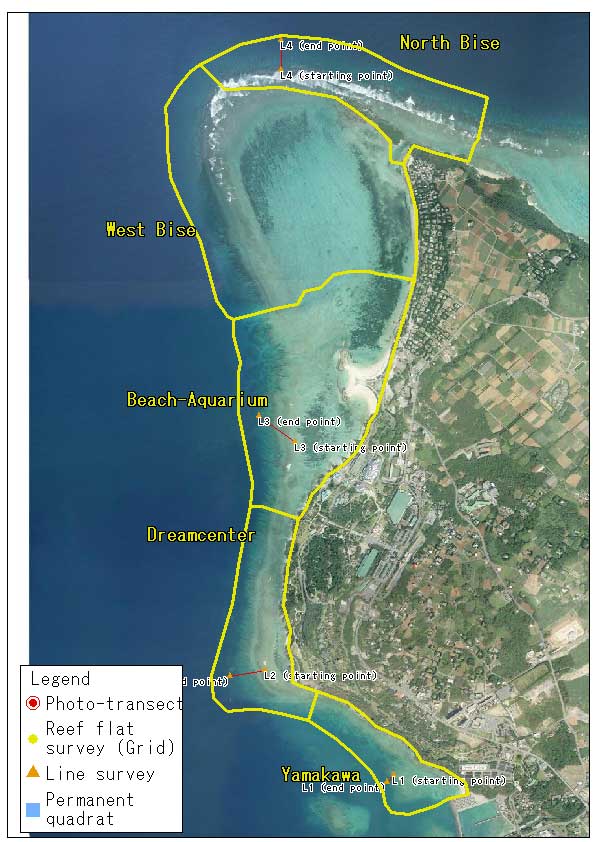
Previous coral reef monitoring program implemented between 1988 and 2003 involved Line survey, which aimed to describe the profile of coral reefs and the vertical distribution of corals. At that time, three transect lines were placed from the beach in a direction toward the reef slope. Our current monitoring program took over these lines, except for the inner reef flat, in order to complement the photo-transect or the quadrat survey that do not cover the vertical changes in coral communities. Line survey has been continued in three year interval since 2006.

Download "Line_Survey_2012" (kmz format, 350 b)
Reef profile and vertical coral distribution pattern for each transect can be viewed on Google Earth
Download Google Earth
Line survey procedure
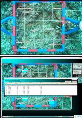
Line survey is conducted by a minimum of 4 scuba divers. The first diver lays a glass fiber transect line in the direction of the reef slope (10-15m depth) from the designated starting point near the reef crest. The second and the third diver place a 2m x 2m PVC quadrat along the transect line in 10m interval and photograph the quadrat with a digital camera. The fourth diver records the position of each of identified coral colonies within the quadrat. Digital images are analyzed using a PC with the software called Coral Point Count (CPC; Kohler and Gill, 2006; US National Coral Reef Institute, www.nova.edu/ocean/cpce/). An observer identifies a coral occurring within the quadrat and trace its outline using either a tablet input device or a mouse. After entering the data into the PC, CPC automatically calculates projected area of each colony and generates a data table in EXCEL format. Percent cover of each colony is then calculated as the proportion of projected area against the area of the quadrat.
Line survey results
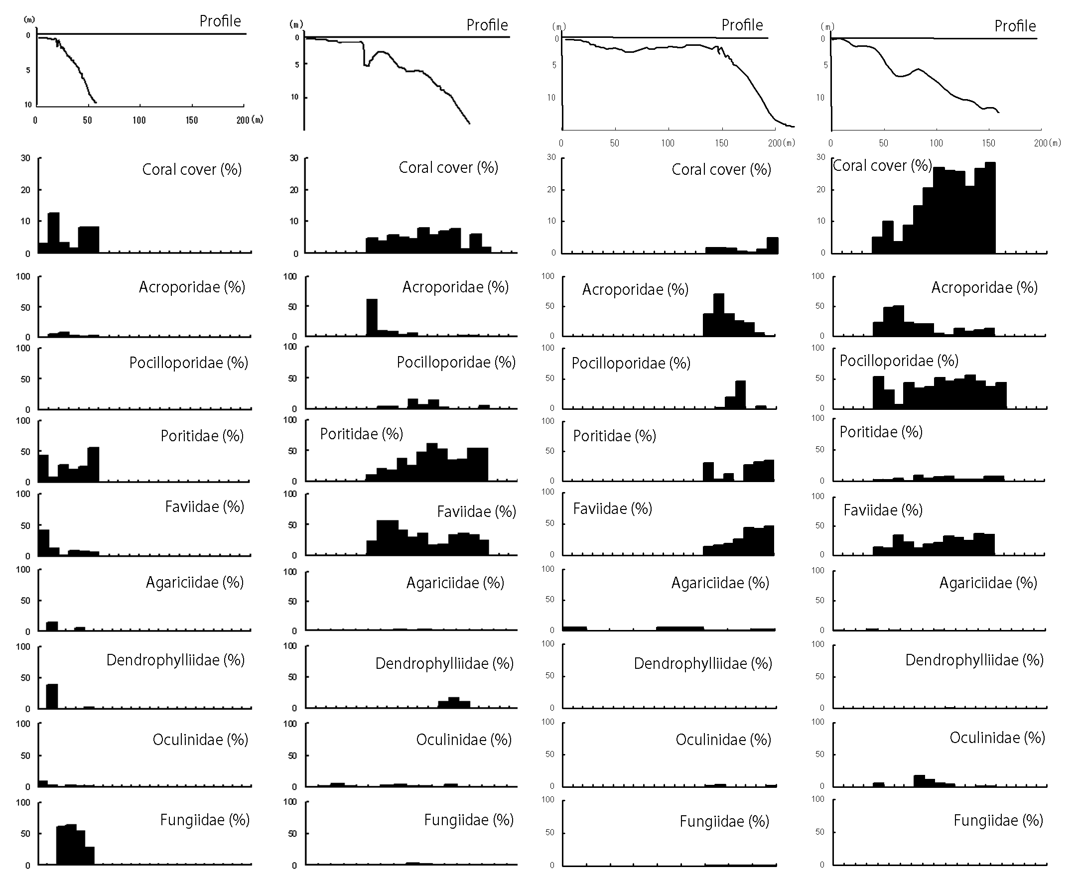
Line 1
- In 1988, Line 1 was originally laid across the reef flat and reef slope near the south end of Yamakawa site. At that time the bottom substrate in the zone between 0m and 100m was either rock or rubble. There was a dense coral community with Acropora intermedia in the zone between 100m and 170m.
- In the period between 1994 and 1998, the Acropora community had been devastated by the Crown-of-Thorns Starfish and it was altered to soft coral community.
- In 2006, the starting point of Line 1 was newly located at the point which correspond to the 150m point of the old transect. The rocky bottom in the zone between the starting point and the depth of 6m was steep, but the slope deeper than 6m was gentle and covered with rubble.
- In 2012, coral cover was in the range between 1.7% (30m point) and 12.5% (20m point). Dominant corals were Poritids and Faviids (0-10m), Dendrophylliidae (10m point) and Fungiidae (40m-). Acroporids and Pocilloporids were rarely found.
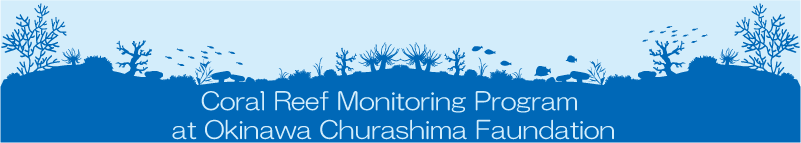
Line 2
- In 1988, Line 2 was originally laid across the reef flat and reef slope in front of Dream Center. The zone between 0m and 100m was intertidal in which small Porites colonies were sparsely found. The reef slope became relatively steep beyond the 150m point.
- In 1989, coral cover on the upper reef slope was below 5%, but it increased to more than 50% in 1994. This was due to the rapid recovery of Acropora community.
- In 1998, the Acropora community on the upper reef slope disappeared from mass-bleaching event and it has never recovered since then. On the lower reef slope beyond the 150m point, small colonies of Poritid and Faviid corals were commonly found, but coral cover has been consistently low.
- In 2012, coral cover throughout Line 2 was in the range between 1.5% (150m point) and 7.9% (110m point). The dominant corals were Acroporids (0-60m points), Faviids (70-100m points) and Poritids (100m point and beyond).
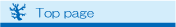
Line 3
- In 1988, Line 3 was originally laid obliquely across the reef flat and the reef slope in front of Okinawa Churaumi Aquarium. The reef habitats were divided as follows: 0-160m, the reef flat; 160-310m, the reef crest and the gentle upper reef slope; 310-420m, the steep reef slope.
- In 1994, Acropora community having high coral cover (>50%) was formed on the upper reef slope, where coral colonies were rarely found in 1989.
- In 1998, the community died from mass-bleaching event. Since then a few small Acropora colonies occasionally appeared, but a stable community has never recovered.
- In 2012, coral cover throughout Line 3 ranged between 1.5% (190m point) and 10.1% (210m point). At the 160m point, there was a small Acropora community, although coral cover was low. The dominant corals transitioned from Acropora to Pocilloporids, Poritids and Faviids with increasing depth.
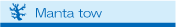
Line 4
- Line 4 was newly installed on the reef slope north west of Cape Bise in 2006.
- The starting point (0m point) was placed on the gentle slope near the reef crest. The slope was steep in the zone between the 40m point and the 70m point (about 7m depth), where the bottom was elevated 1-2m. Then the slope became steep again beyond the 80m point.
- In 2012, coral cover throughout Line 4 was in the range between 3.7% (60m point) and 28.5% (150m point). Pocillopora was the dominant coral of this line except for the 50m point and the 60m point where Acropora community was found.